
Native Astorians & the Legend of Sunswick Creek
It goes without saying that before any of us ever called Astoria home, whether it be immigrants or those who have migrated here from other states and cities, ancient peoples once walked the land now completely over developed by high rise co-ops, warehouses producing advanced technologies and various businesses large and small. Who were these people and how did they live?
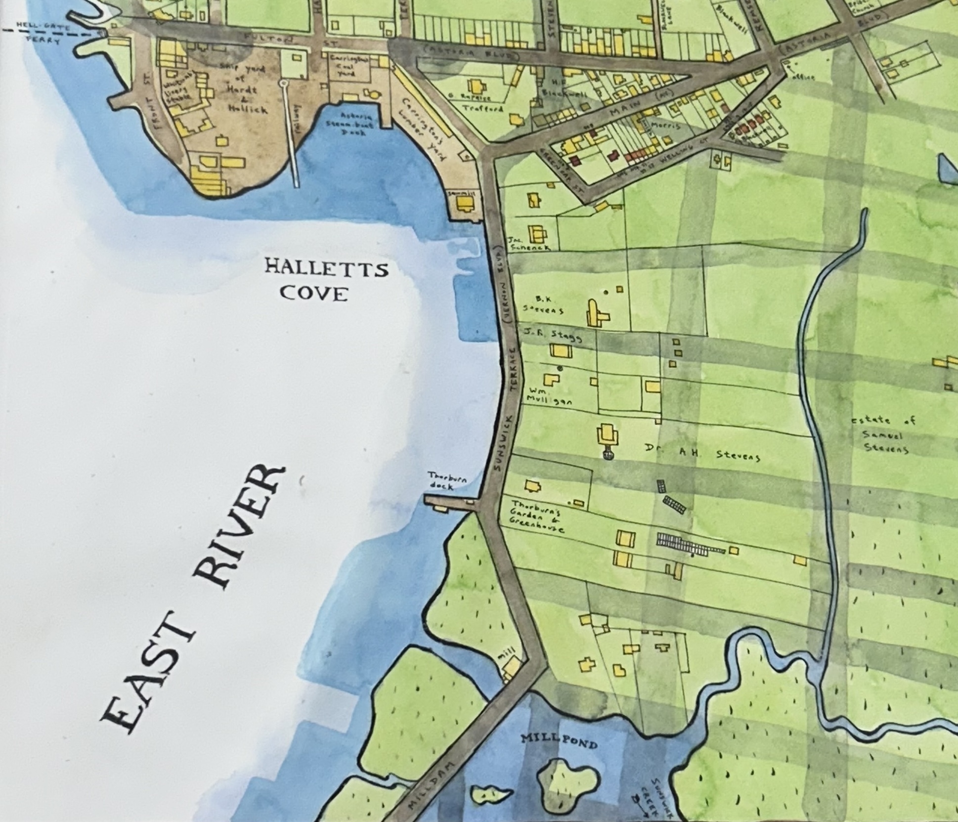
The Lenni-Lenape speaking Algonquin are the indigenous people who first called Astoria their home. They settled near Astoria Park where they fished and caught stripped bass, black fish and weak fish in the waters of the Hell Gate River and hunted deer in the wooded area further inland near present day Jackson Heights. The Algonquin also fished the enormous marshlands which faced the East River. Running along the length of what would later become Vernon Boulevard beginning from its northern most section near Astoria Boulevard and meandering its way south to the Queensboro Bridge was a flowing body of water known as Sunswick Creek. The creek’s name comes from the Lenni-Lenape language and pronounced “Sunkisq” which means “Woman Chief” or “Sachem’s Wife.” A sachem is the Indian word for chief. The creek passed north near the current site of the Queensbridge Houses and the Ravenswood Generating Station roughly following a path parallel to present day 21st Street. The Native Americans referred to the entire area as ‘Matinecoc’ or English, “The Place of Hills” or “The Hunting Place”.
In the mid 1600s the Dutch colonized the territory and named it New Netherland after their home country and their seat of power became New Amsterdam which is of course today Manhattan island.
When the Dutch authorities at New Amsterdam wished to reward one of their own for their hard work in helping to grow and benefit the colony, they would assigned a tract of land in the “Outter Plantations” or western shore of Long Island. It was in this way that Astoria first emerges into history. The first resident of Astoria was Jacques Bentyn, a director on New Netherland Director General Wouter Van Twiller’s council and a member of the Dutch West India Company. Bentyn obtained the land grant in 1634 of about 160 acres, covering the peninsula which is today Hallett’s Point. The first structure ever built in Astoria was north of Astoria Boulevard near the intersection with Vernon Boulevard just a few yards from Sunswick Creek.
The Algonquin and the Dutch had got along very well together until some Dutch settlers, motivated by expansionist desires declared war upon the natives in February 1643 and killed a large number in Jersey City and Manhattan. Angry at the disturbed state of affairs in New Netherland, Governor Van Twiller was removed as ruler of the colony in 1647 and replaced with a new governor, Peter Stuyvesant. Shortly thereafter Bentyn deserted his plantation in Astoria and returned to Manhattan for safety during the period known as the Indian Wars.
Five years later, William Hallett, an Englishman, applied for the abandoned Bentyn plantation and received it as a grant from the new Director General Stuyvesant. The original deed for this land grant, signed by four Indian chiefs by their marks and witnessed by three Dutch men, still exists in the State Archives in Albany. It reads as follows, “I, Peter Stuyvesant, doth declare that on the day of the date hereunder written, the hath granted and allowed unto William Hallett a plot of ground at Hell Gate upon Long Island called Jaques farm beginning at a great rock that lays in the meadow, and goes upward southeast to the end of a very small cripple bush…This done the 1st of December 1652 in New Amsterdam in New Netherland.”
Stuyvesant strove to maintain peace with the Indians but one of his men who had a farm near Exchange Alley in downtown Manhattan killed an Indian trespasser and this incident touched off a renewed outbreak of hostilities with the Indians. In September 1655, the Indians attacked Manhattan and other raiding parties ravaged Jersey City, Staten Island and the Long Island shore.

In August 1664 Hallett bought another huge tract of land in Astoria from Algonquin Chief Mattano, sachem of the Staten Island & Noyack (Fort Hamilton) Indians, for 58 pieces of wampum, seven coats, one blanket and four kettles. The tract embraced 2,200 acres, extending from the Flushing Bay to Sunswick Creek, which included all of modern Astoria and Steinway.
At the present intersection of 26th Avenue and 12th Street was a 57 foot hill, the highest point in Astoria, and from here the Halletts could lookout over their acreage. Hallett’s farm was surrounded by trackless forest and swampy meadows. To keep the salt water out at high tide, the Halletts as early as 1679 built a dam across the mouth of Sunswick Creek which continued to be maintained for almost 200 years. South of their farm house was an orchard located along the high ground near the street known as Sunswick Terrace (now Vernon Boulevard) and east of that the swamp land and meadows all met at Sunswick Creek where it collected into a huge pond at 11th Street and Broadway known as The Mill Pond. As the year 1700 approached, the Algonquin had lost all of their land in Queens. Their final settlement was further East in Little Neck, Queens. It was here that the last tribe was pushed further east into Long Island in what history has come to call, “The Battle of Madnan’s Neck’.
The 20th Century saw the coming of major development in Long Island City which brought an end to Sunswick Creek and its marshy surroundings which had by this point grew stagnant and polluted with sewage and industrial discharge. This problem persisted and got worse, and the LIC communities of Dutch Kills, Astoria, and Hunters Point suffered from outbreaks of smallpox, diphtheria and mosquito borne diseases like malaria. When the Queensboro Bridge was built in 1908, the city began to fill in the creek. The operation had a projected total cost of $100,000 (equivalent to apx. $3,100,000 in 2024).
Today there still remains traces of Sunswick Creek! The last surviving part of the creek is visible behind Socrates Sculpture Park where it borders the BJ’s parking lot. The name also lives on in the form of a local favorite restaurant Sunswick 3535, at the intersection of 35th Street and 35th Avenue. Patrons can enjoy the Sunswick salad made with fresh baby arugula, fuji apples, dried cranberries and goat cheese covered with pistachios and raspberry vinaigrette. Another interesting find is a free virtual walking tour of the old pathway of Sunswick Creek by visiting, https://www.cityaslivinglab.org/callupdates/post_id-1
Additionally, the present-day 22nd Street was formerly named Sunswick Street almost a century ago.


